The Sawlog Fire, currently covering an area of approximately 2,020 acres with a containment level of 65%, is located 15 miles northeast of Wisdom, Montana, within the Sawlog Creek drainage. The fire ignited on May 1, 2025, and the cause remains under investigation.
Firefighting crews have implemented strategic firing operations along both sides of Sawlog Creek, prioritizing containment efforts while actively monitoring for hot spots. The fire predominantly affects areas of sagebrush and Lodgepole pine, contributing to hazardous conditions due to the significant presence of dead vegetation and numerous hazardous trees. This combination of fuels has resulted in irregular fire behavior, which is atypical for this season, particularly given the prevailing dry conditions.
In light of the fire’s impact, the Montana Fish, Wildlife and Parks has enacted an emergency closure of the Fishtrap Creek Fishing Access Site along the Big Hole River to safeguard public welfare. Additionally, the Bureau of Land Management has issued a temporary closure of the dispersed camping area located at the ford site on the Big Hole River.
Fire management officials are collaborating with local agencies and interagency partners to safeguard critical values at risk while mitigating potential damage to resources. As warm and dry weather persists, the likelihood of increased fire behavior is a growing concern, necessitating ongoing vigilance and preparedness.
As of May 9, 2025, the Big Creek Fire is classified as an ongoing wildfire, encompassing an area of 75 acres. This fire originated on May 7, 2025, and its cause remains undetermined pending further investigation. This incident is located approximately 9.5 miles west of Stevensville, Montana, in a challenging landscape characterized by rocky, steep terrain adjacent to the valley bottom of the Big Creek Drainage, reaching up to the snow line.
Fire management personnel are currently using helicopters to execute targeted water drops, given the difficulties associated with accessing this region by ground personnel or engines. These helicopters are operating within the vicinity of the mouth of the Big Creek Drainage to obtain water for aerial suppression efforts. Drones are prohibited in this area, as their presence poses significant risks to flight operations.
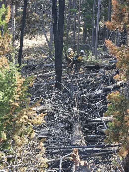
Assigned personnel are monitoring the current situation from an elevated position on the southern side of Big Creek, while also evaluating the lower portion of the fire for potential containment strategies. To ensure safety and effective management of the area, a closure order is being implemented for the Big Creek Trailhead in Stevensville.
Please continue to monitor the Great Falls Gazette for ongoing updates as we endeavor to provide pertinent information throughout the fire season. Additional information is available at https://inciweb.wildfire.gov/.

Author: Karen Anderson
Karen is the Editor-in-Chief overseeing all news operations at Foxys Publishing Co. She also loves photography and spending time with her dogs.