The fire season has begun this year beginning with the Sawlog Fire. The following information is presented with information gathered from https://inciweb.wildfire.gov/ updated as of May 3rd.
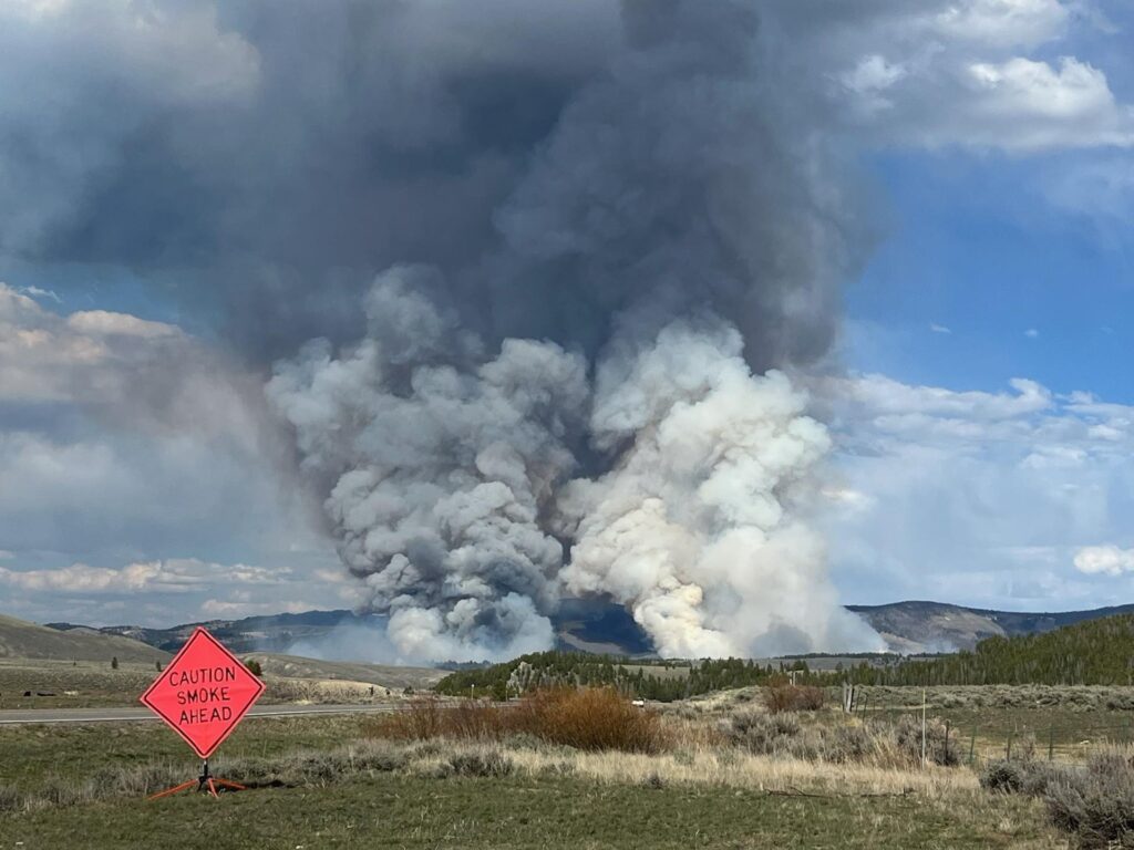
The Sawlog Fire was reported on the afternoon of May 1st. Fire officials from the Beaverhead-Deerlodge National Forest responded to the incident area, which is located west of Wise River and northeast of Wisdom within the Sawlog Creek drainage. The initial estimate indicates that the fire covers approximately 50 to 70 acres, with its location on the south side of the Big Hole River. Access to the fire area has been somewhat restricted due to seasonal snowmelt and elevated water levels in the river. Upon arrival, firefighters observed active burning in sagebrush and Lodgepole pine timber, with a considerable amount of dead and downed fuel present on the north-facing slopes.
The fire is positioned between the Sawlog Creek and Toomey Creek drainages, on the southern side of the Big Hole River. Updated mapping confirms that the fire is impacting lands managed by the Forest Service and the Bureau of Land Management. Notably, the footprint of the 2021 Christensen Fire is located to the south.
Investigators are currently working to ascertain the fire’s precise cause. As of May 3rd, this fire was 383 acres in size and 5 percent contained.
The fire predominantly affects sagebrush and Lodgepole pine timber. The north-facing slopes in the vicinity contain a significant accumulation of dead and downed fuels. The fire has demonstrated moderate behavior, characterized by flame lengths of 3 to 5 feet in the sagebrush, along with isolated torching, group torching, and crown runs within the timbered areas.
A 20-person crew was deployed on May 3rd to augment the existing team of 31 firefighters. They will employ a helicopter for water bucket drops and execute strategic firing operations. Efforts will prioritize the area along Sawlog Creek Road, extending northward to the Big Hole River (eastern edge of the fire), as well as the region along Toomey Creek, northward to the Big Hole River (western edge of the fire). The footprint from the Christensen Fire of 2021 lies to the south.
The implementation of strategic firing operations is designed to enable crews to burn the fuels located between the active fire edge and the established control lines along roads and natural barriers. This fire suppression technique is instrumental in reducing available fuels in advance of an active fire edge, thereby mitigating the potential for resource damage and minimizing the adverse effects associated with high-severity fires on timbered slopes.
Collaborating with local and interagency partners, fire managers have identified and prioritized critical values at risk from the Sawlog Fire. Their planning is of a strategic nature, focusing resources on the reduction of available fuels ahead of the active flanks of the fire while striving to diminish the potential for negative impacts and resource damage.
Please continue to monitor the Great Falls Gazette for ongoing updates as we endeavor to provide pertinent information throughout the fire season. Additional information is available at https://inciweb.wildfire.gov/.

Author: Karen Anderson
Karen is the Editor-in-Chief overseeing all news operations at Foxys Publishing Co. She also loves photography and spending time with her dogs.