The Colt Fire started 15 miles northwest of Seeley Lake on Monday, July 17, which was reportedly started by lightning. This fire as of July 30th was 6,177 acres in size with 6% containment. Firefighters have been working hard to control the fire, which has increased due to higher temperatures and lower humidity.
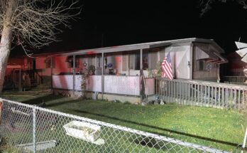
Fire crews continued operations to secure the fire’s edge along the southeast corner near Forest Road 646 (Colt/Uhler Road). On the east side of the fire, crews are working to increase the containment percentage by mopping up along Forest Road 646, moving north. Helicopter bucket water drops were used to support burning operations. On the fire’s north side along Forest Road 906 (Beaver Creek Road) and other roads, the Heavy Equipment Task Force continued to prepare control lines and mitigate fuels along roadsides in locations that have a high probability of success to contain the fire. South Structure Protection worked on structure assessments and preparation, and North Structure Protection assisted in operations along Forest Road 646 (Colt/Uhler Road) while being prepared to implement structure protection plans if conditions changed.
On the southeast corner of the fire personnel will continue firing operations and secure the line north of the West Fork of the Clearwater River and tie in with Forest Road 646 (Colt/Uhler Road). Crews will continue to hold and mop up along the eastern control lines along Forest Road 646. On the north side, crews will hold and secure the fire along Forest Road 4356 and look for opportunities for fire control line from Colt Lake to Beaver Lake. North and South Structure Protection will assist with burning operations and holding operations on the east and southeast sides of the fire. Structure Group remains ready to respond for structure protection as needed. A night shift of engines and personnel will patrol and monitor fire conditions. Helicopters and airplanes will be used to drop water and retardant on the fire as needed.

EVACUATIONS AND CLOSURES
The Missoula County Sheriff’s Office Evacuation Warning and Order summary:-Residents on Beaver Creek Road (near the summit) are under an Evacuation Warning.-Mile marker 31 (Beaver Creek Road at the intersection of Hwy 83) south towards Seeley Lake to mile marker 27, and including residences in Rovero Flats, are under an Evacuation Order.-Residences beginning at mile marker 27, south end of Rovero Flats, to mile marker 25.5 (the intersection of the West Fork of the Clearwater Road and Hwy 83) are under an Evacuation Warning.-Residences on the north and south ends of Lake Inez are under an Evacuation Warning. The east side of Lake Inez, along Hwy 83, is not under any Warning or Order.
If conditions rapidly change an Evacuation Order may be issued with no prior notice or warning. Home and property owners in the surrounding area should remain vigilant and prepared. Have an evacuation plan for family, pets, and livestock; sign up for emergency alerts at Smart911.com; be familiar with the Missoula County evacuation process and what an order and warning means.
Evacuation information can be found at: https://www.missoulacounty.us/government/public-safety/office-of-emergency-management/evacuation-information
The Lolo and Flathead National Forests have closed several forest roads, areas, and campgrounds near the fire area for public safety. The list of current closures includes:-Forest Road 906 (closed at Highway 83)-Rainy Lake Campground access road 4357 (closed at Highway 83)-Rainy Lake Campground-Alva Lake Campground access road (closed by gate at Highway 83)-Alva Lake Campground-Lakeside Campground access road (closed by gate at Highway 83)-Lakeside Campground-Lake Inez Campground-Forest Road 646 (closed at the junction of FSR 552; FSR 4354; Forest Road 552 (beyond the turn off to west side Lake Inez access-Forest Road 5407 and 463 closed beyond the West Side snowmobile trailhead (these roads access the Montana Fish, Wildlife, and Parks Marshall Wildlife Management Area and Lake Marshall)-Temporarily closing the Forest System Road loops of the Clearwater (FSR 4370 and 4353) and Richmond (FSR 667 and 720)

TEMPORARY FLIGHT RESTRICTIONS
A Temporary Flight Restriction is in place for air space over the Colt Fire (FDC 03/0291) to provide a safe environment for firefighting aircraft operating in the area. An airport closure is in place for the Condon Airstrip (FDC 07/110) for firefighting helicopter operations. Remember that temporary flight restrictions also apply to unmanned aircraft systems (UAS) or drones. A drone incursion occurred on Friday, July 21. Fire managers would like to remind the public that when you fly, they can’t. It is also now a criminal misdemeanor in Montana to fly drones that interfere with fire suppression efforts – with a fine up to $1,500 and the violator has the potential to be charged with firefighting costs.
If you are evacuated due to the Colt Fire and need shelter, please call the Red Cross at (406) 215-1514.

Author: Karen Anderson
Karen is the Editor-in-Chief overseeing all news operations at Foxys Publishing Co. She also loves photography and spending time with her dogs.